

Official Newspaper of Eddy County since 1883
Official Newspaper of Eddy County since 1883
Area co-op observers also see record snowfall
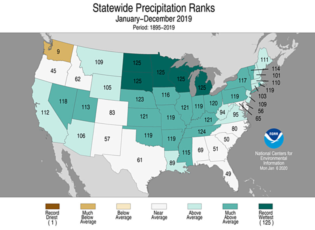
This chart prepared by the National Centers for Environmental Information demonstrates that the Dakotas and the Great Lakes states saw their wettest year on record, and most of the Midwest had above average precipitation in 2019.
Weather is often a topic of conversation here in North Dakota, considering the extreme temperatures, snow, wind and severe weather that residents experience. The talk gets even more prevalent in times such as last October when the area saw above average rainfall followed by a blizzard that brought more than 2 feet of snow.
Events like that make journalists here at the Transcript even more curious about how the weather compares to other years outside of our immediate frame of reference.
To get the answers to our pressing weather questions, we reached out to Gregory Gust at the National Weather Service in Grand Forks, and he shared some incredible data with us. The information was compiled by cooperative observers who either volunteer or contract with NWS to observe and record data about the weather in a particular area.
While Eddy County does not have an observer, the data compiled at a few nearby stations in Carrington, Jamestown and McHenry is indicative of what we've experienced. Here we share some of the highlights:
Wringing wet
Governor Doug Burgum was serious when he said this fall's flooding was an "unprecedented situation," and NWS data backs up his claim with science. As noted in the above chart, North Dakota saw its wettest year on record since 1896. The cooperative stations in nearby towns were no exception. McHenry recorded 24.13 inches of rain, 50 % higher than the average of 16 inches. This is the most on record since 1996, when observations began there. Snowfall and the subsequent precipitation that results from snow melt is not recorded in McHenry, so the total precipitation is higher. Jamestown saw its fourth wettest year in over a century, at 24.33 inches total precipitation. The record of 31.81 inches was set in 1993. Carrington had 29.53 inches of precip through the end of November, which was just shy of the record rainfall from 1993 of 30.01 for the full calendar year. As December data had not been entered as of press time, Gust said it is likely that Carrington set a record for the wettest year since 1967.
Record snowfall
Jamestown saw more than 104 inches of snow in 2019, a total that beat the nearest record of 81 inches set in 1896. While the December data for the Carrington station has not been entered into the system, the January through November number is the highest on record since 1967, when they first began observations there. The total annual snowfall recorded through Nov. 30 was 77.6 inches, compared to the average of about 32 inches. No wonder snow removal was about all the county and city commissioners could confer about during their meetings last week!
Shiver me timbers!
The average temperature in our area is around 40 degrees. The 2019 average in Jamestown came in at 38.5 degrees, the 12th coolest since 1895. The record of around 37 degrees is shared by 1916, 1917, 1950 and 1951. Therefore, it's definitely been awhile since residents have seen temperatures colder than they were in 2019. McHenry's 2019 average is equal to Jamestown's record of 37 degrees, but wasn't even the coldest on record since 1996, which was 35 degrees that year. The normal annual temperature in Carrington is slightly lower than 40, around 39.7 degrees. Through the end of November, Carrington had recorded its fourth coldest year, behind 1978, 1996 and 1979. Gust estimated that Carrington would end the year at around 37 degrees on average.
Since 1890, cooperative observers have been recording weather and climate data throughout the country. The National Weather Service (NWS) Cooperative Observer Program is the nation's weather and climate observing network with more than 8,700 volunteers. The observers provide observational meteorological data, including daily maximum and minimum temperatures, snowfall, and 24-hour precipitation totals, required to define the climate of the United States and to help measure long-term climate changes. The data they record is also used in near real-time to support forecast, warning and other public service programs of the NWS.
The Transcript is considering pursing a cooperative observation partnership with NWS. Are there any readers who might be interested in participating by collecting data? Let us know what you think. We appreciate your feedback.


