

Official Newspaper of Eddy County since 1883
Official Newspaper of Eddy County since 1883
Courtesy of National Weather Service- National Oceanic and Atmospheric Administration (NOAA)
School kids, local officials take "cold weather day(s)" as temperatures plunge
School's out for winter! School's out due to cold air!
Students at area schools could be heard singing a version of Alice Cooper's popular last-day-of-school tune as they snuggled up at home this past week. Well, maybe it was their parents who did the humming.
With temperatures plunging to nearly 40 degrees below zero with wind chill readings even lower, classes at New Rockford-Sheyenne School were canceled both Tuesday and Wednesday, and school didn't resume until 10:30 a.m. Thursday morning. The Eddy County offices were closed Wednesday, the U.S. Postal Service suspended mail delivery, and even New Rockford City Auditor George Ritzke went home at noon.
Meanwhile, the reporters here at the "New Rockford Transcript" were diligently performing our civic duty to record actual temperatures and conditions for historical purposes. The coldest actual air temperature recorded in Eddy County, per the National Weather Service, was 38 degrees below zero early Wednesday morning. Several residents unofficially reported the same.
A few hours later, safe inside our 72 degree office downtown, we set to compare New Rockford's temperatures to that of other notably cold places on the planet. As of 11 a.m. Wednesday, New Rockford's temperature was slightly warmer, at 25 degrees below zero. Media outlets across the country talked and wrote about the "polar vortex" and its effects on their areas. Anchorage, Alaska reported a temperature of 34 degrees at that hour. Chicago boasted its "frigid" 18 degrees below zero. The headline on WISC-TV's website in Madison, Wis., declared that "It was colder outside in Madison than in Alaska, Antarctica and Hell," noting that the city's temperature had reached 26 below zero. Here in North Dakota, Lake Metigoshe (north of Bottineau) got the "freezer" honor with an actual air temperature of 49 degrees below zero.
Speaking of freezers, Bakers Dozen owner Kelly McKnight reported that the thermometer inside her freezer that morning read 4 degrees, nearly 30 degrees warmer than it was outside!
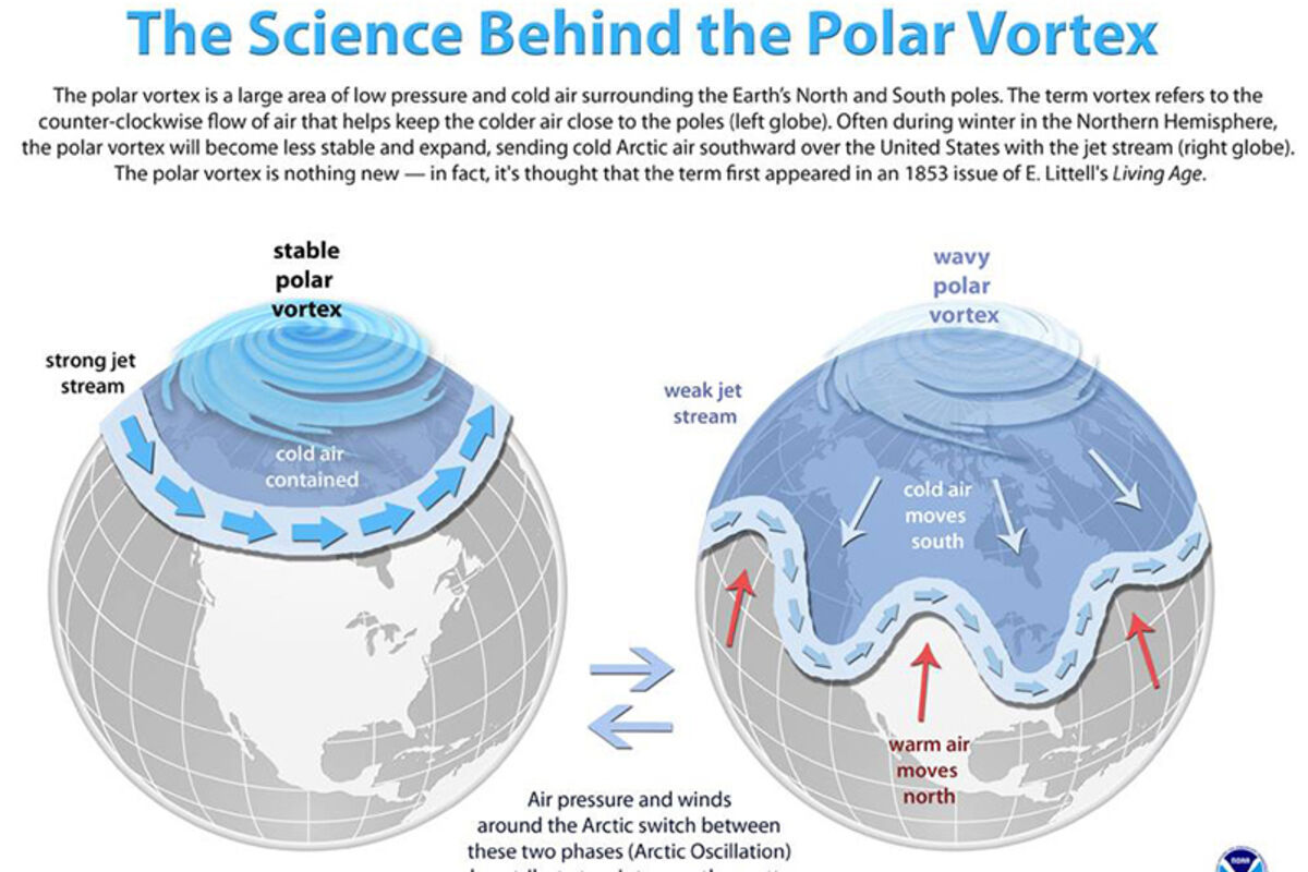
So what is all this talk about a polar vortex, and what does it all mean? The polar vortex actually is a seasonal atmospheric phenomenon, a system of strong, high-level winds – called the jet stream – surrounding an extremely cold pocket of Arctic air. And while it might sound like a malevolent force of nature, the polar vortex for the most part is a good thing, because its winds form a boundary that keeps the cold air contained and prevents us from freezing.
The polar vortex is weakest during the warmer months of the year, when there's less of a contrast between polar temperatures and those in warmer regions. The vortex strengthens in the winter, though, to keep cold air in the Arctic and prevent the rest of the Northern Hemisphere from getting too frigid.
Once in a while, though, the polar vortex breaks down. The result is a strong blast of Arctic air that travels far south, causing the temperature to plunge here in the U.S.
While the polar vortex might seem like a "cool" new phenomenon, cold snaps caused by distortions in the vortex are not new. In January 1985, for example, the northern polar vortex was really distorted, and polar air pushed into the eastern U.S. all the way south to Florida. Ninety percent of the state's citrus crop was destroyed. The parade and outdoor ceremony for President Ronald Reagan's second inauguration had to be canceled, and at least 126 people died, according to the NOAA.
The coldest actual air temperature ever recorded was at Vostok Soviet Experiment Station in Antarctica. Instruments there recorded a frigid 128.6 degrees below zero on July 21, 1983. Antarctica is on the south pole, so its seasons are the opposite of ours. Therefore, this time of year it is the height of the "warm" season. The temperature in parts of Antarctica at 11 a.m. Wednesday reached 59 degrees! In Vostok, though, the air is extremely cold, with average temperatures below zero year-round.
Mike McFeely, columnist for "The Forum" wrote about a 1936 cold snap that lasted more than a month. Temperatures first dipped below zero on Jan. 15 and stayed at or below zero until Feb. 21, a period of 37 consecutive days. The temperature did reach zero on two separate days, but didn't climb above. When the spell finally ended on Feb. 21, the recorded high temperature was 8 degrees. Two days later, the high was 30 degrees. Even the low temperature stayed above zero at 9 degrees.
Forecasters say this is not likely the last cold snap of the season. As of Thursday, when temperatures had risen to just 3 degrees below zero, the National Weather Service issued a prediction that there was a 90 percent chance that temperatures would remain well below average all this week. Stay warm, dear readers!


